Listed in Arkansas Register of Historic Places on 04/07/10
SUMMARY
The Round Top Mountain Crash Site is being nominated to the Arkansas Register of Historic Places with local significance under Criterion A for its significance
in the history of aviation in the Jasper area and for its association with World War II aviation and home front activities.
ELABORATION
Round Top Mountain has always been a prominent landmark in Newton County, having a distinctive outline and being highly visible. It was long in private hands and was settled by local families. The Newton County Resource Council obtained ownership of 158 acres of the mountain in 1997 when the land was donated by William Stiritz, son of a pioneer doctor in the town. Since the remainder of the mountain was owned by the county government, it was the opportunity for a park to be created there. Twenty acres is leased from the county on the south side of the mountain. It has long been a popular gathering place for people in the county because of the spectacular 360 degree views enjoyed from the summit. Highway 7, the main north-south road through the county, runs along the east edge of the property.
Newton County has remained a very rural sparsely populated county even today because of the rugged nature of the terrain. It was home to prehistoric bluff dweller Indians and there are two significant archeological sites along the bluffs in Round Top Park. The county was settled by immigrants in the early 1800’s who came to trap and hunt. Later, timbering became the major activity and it remains so today along with tourism. The nearby Buffalo National River was established in 1972 and draws many visitors to the area. Many visitors continue to come to Newton County to hike the trails, canoe the rivers, camp out or take advantage of the many log cabins for rent. The annual Elk Festival continues to draw more and more visitors as the elk herd grows.
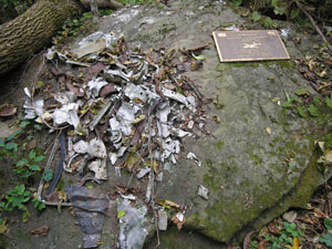
The night of the crash, February 6, 1948, the weather was horrible with freezing rain and fog. The B25 was flying from Dayton, Ohio, to Little Rock, Arkansas, with five men aboard. It was a military plane, a bomber, but was not armed on that flight. It was being used for training purposes. The local people reported hearing and seeing the plane flying very low the night of the crash. It was lost and off course and the plane was icing up. It crashed into the bluff at 8 pm that night causing a large explosion that shook windows all around. Bodies and debris from the plane were scattered all around the site. Many local people were at a basketball game in Jasper at the time of the crash. When they got the news, several of them went with the sheriff to search the site and stayed to guard the scene through the night. There were many small explosions going on as the scattered fuel pockets caught fire. Locals said it was a gory sight but the full impression could not be known until morning light. The plane was broken into many small pieces, the biggest being the two engines, one of which was imbedded in the bluff where the plane hit, and a portion of the tail section.
Today there is a trail to the crash site. The place where the plane crashed into the bluff can be seen and the scorch marks from the burning fuel are visible on the rocks. One of the plane engines is on display at the site. There are pieces of metal and aluminum parts that have been found and some are still lying in the soil. Local people gathered pieces of the plane and have offered to give them to a museum if one is established.
The B-25 bomber was a military plane in very common use during World War II. It had two engines with 14 pistons per engine which each weighed over 1000 lbs. It was made mostly of aluminum and was 52 feet long with a 67 foot wing span. It could fly at 272 mph with a range of 1350 miles and 24,000 feet. Over 11,000 were built and about 260 remain in existence today.
Round Top Mountain Park already has about 4 miles of trails that were constructed since 2001 with an Arkansas Recreational Trails grant and funds from the Dept of Transportation. The trail to the crash site was constructed as a handicapped accessible trail. There is a concrete block building that serves as an interpretive center at the trailheads. Ecotours of the crash site were conducted for several years in 2002-3 but were discontinued when Ray Crouse, the guide, became ill. In June 2000, the trails in the park were designated as White House Millennium Trails by Hillary Clinton. Highway 7 that runs along the east side of the property and provides access to the property is designated a Scenic Byway and is among America’s top 10 scenic highways.
Since opening to the public in 2001, the park has been very popular with visitors and hikers. It is one of the most accessible hiking trails in the county being only 1 mile from Jasper and right off Highway 7. Aside from the views, the natural features of the site including the bluffs, rock formations, trees and wildflowers are spectacular. The B-25 crash site offers a fascinating glimpse into the past and tells a dramatic story that is an integral part of the history of the country.
SIGNIFICANCE
The Round Top Mountain Crash Site is being nominated to the Arkansas Register of Historic Places with local significance under Criterion A for its significance
in the history of aviation in the Jasper area and for its association with World War II aviation and home front activities.
BIBLIOGRAPHY
B-25 Air Crash Video, 1999, interviews with J.E. Dunlap, Jack Harrison, Wallace Harrison, Ray Crouse
Articles by J.E. Dunlap, Boone County Headlight, February 12, 1948.
Maps provided by Newton County Resource Council