Listed in Arkansas Register of Historic Places on 08/05/09
SUMMARY
The Springfield to Fayetteville Road – Brightwater Segment is eligible for listing on the National Register of Historic Places under Criterion A with Statewide
significance by virtue of its status as one of the few segments of road that was traversed in Arkansas as early as 1837 by the B. B. Cannon contingent,
and by eleven of the seventeen Cherokee Removal contingents in 1838 and 1839, and along the road known as the Trail of Tears. The segment retains its
integrity as a nineteenth-century roadbed. Its later association with the Butterfield Trail and northern and southern troop movements surrounding the
Battle of Pea Ridge during the American Civil War augments its importance. The property is being submitted for National Register recognition under
the multiple – property listing “Historic and Archeological Resources Associated with the Cherokee Trail of Tears.”
ELABORATION
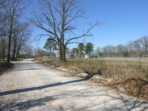
The Springfield to Fayetteville Road – Brightwater Segment constitutes part of what soon after Arkansas statehood would be known as the State Road.It led from Fayetteville, Arkansas, to Missouri’s southern border. The particular segment under consideration was laid out in two segments in 1835, with the first segment beginning in Fayetteville and ending at the homestead of John Fitzgerald. From that point the Washington County Court ordered the construction of the second segment of road “from Fayetteville to the Missouri line in the direction of the Delaware town [near Springfield, Missouri] commencing at or near the second spring north of John Fitzgerald.”[i]
The road continued to Little Sugar Creek, then on to Samuel Burk’s, William Reddick’s, Job R. Monds’ homesteads, and on to the Missouri line. The roadway was to be twenty-feet wide.[ii] It plays a historically significant part not only in Arkansas history, but also in events which shaped our nation’s character and identity. It helped to promote, quite literally, America’s economic and cultural direction while often embedding within its shoulders a tragic legacy of pain and suffering, even death, in its still visible twists and turns. The historic significance of this section of the Trail of Tears centers on the years 1837 to 1839.
A brief statement in the Comprehensive Management and Use Plan, Trail of Tears National Historic Trail, reveals the historic national significance of the Elkhorn Tavern segment. It states: “The Trail of Tears National Historic Trail commemorates the tragic experience of the Cherokee people, who were forcibly removed by the United States government in 1838 – 39 from their homelands in the southeastern United states to new homes hundreds of miles to the west.”[iii] The statement is a remarkably succinct narrative portrait of this highly significant, albeit dark period in America’s history. However, the use of phases such as “tragic experience” and “forcibly removed . .from their homelands” only partially lifts the curtain on this tragedy. Greed, racism, lust, deception, murder are concepts often conveyed in the narrative as well, and help to reveal the complexities of United States history during the Cherokee Removal.
Cherokees were dragged from their homes and lands, shoved into stockades, forced into internment camps in Tennessee, and then herded along water and land routes into Indian Territory. For many of the Native Americans, especially the very young and very old, the Trail of Tears was a death march. This forced march was the antithesis of the American dream.Self-determination, opportunity, and individual freedom were ideals as alien to the Cherokees as they were to those living under tyrannical governments elsewhere in the world.
The Cherokee Removal, the most famous feature of which is the Trail of Tears, could be cynically said to have had its beginnings with the first contact between the Europeans, and the native peoples of this land. One could choose at will any date of contact and get a sense of things to come. Quite simply, Native Americans had what the newcomers wanted – land. Justifications for the seizing of land, be they hatefully racist, kindly religious, or blatantly economic, are as predictable as the outcome.
While the Native Americans themselves became directly responsible for the actual movement of their people, the heavy hand of the United States government made sure they maintained a constant pace westward. Disease and exposure reduced their number by hundreds, if not thousands. Because Arkansas’ geographic location positioned it in the final few miles of this journey, those Arkansans witnessing the Native Americans being driven along the road were observers of the conclusion of hundreds of miles of heartache.
In the 1830s the charade of excuses for taking land fell away, and lands belonging to several tribes, but primarily those of the Cherokee Nation in the southeast United States, were blatantly stolen and those who once had possession were driven far away. President Andrew Jackson encouraged these actions. Jackson even considered the Indian removal compassionate compared to his well-known belief in extermination of Native Americans. Jackson participated in negotiating several treaties with Native Americans whereby the various tribes exchanged their lands for land to the west. He helped to guide the Indian Removal Act through Congress in May 1830, which is viewed as the beginning of the formal removal program. It was to “provide for an exchange of lands with the Indians residing in any of the states or territories, and for their removal west of the river Mississippi.”[iv]
The Cherokee Nation became more and more isolated due to white incursions. By 1835, no fewer than twenty-three treaties had been signed with the last, the Treaty of New Echota, signed on December 29, 1835 (and repudiated by the vast majority of Cherokee. In fact, it was signed by only 100 of the 17,000 Cherokees living there). This treaty forced the Cherokees toforfeit all their remaining Cherokees lands east of the Mississippi River to the United States government. [v]
As the state of Georgia began anew the forcible round-up for removal, the Cherokee Nation proved the legal right to its land in the United States Supreme Court. They would take that decision with them on their journey westward.[vi] The abuses exacted upon the Cherokees at the beginning of the long journey foretold the hardships to come. James Mooney, an ethnographer who later interviewed a several Cherokees who survived, states:
"[O]n turning for one last look as they crossed the ridge, [the captives] saw their homes in flames, fired by the lawless rabble that followed on the heels of the soldiers to loot and pillage. So keen were these outlaws on the scene that in some instances they were driving off the cattle and other stock of the Indians almost before the soldiers had fairly started the owners in the opposite direction . . . To prevent escape the soldiers had been ordered to approach and surround each house . . . so as to come upon the occupants without warning. One old patriarch when thus surprised calmly called his children and grandchildren around him, and kneeling down, bid them pray with him in their own language, while the astonished soldiers looked on in silence. Then rising he led the way into exile.[vii]
The earliest contingent of Cherokees to come along the Springfield to Fayetteville Road – Brightwater Segment was under the charge of conductor B. B. Cannon. Fortunately, Cannon kept a journal of the passage. Those contingents following thereafter repeated Cannon’s route, coming into Arkansas from Missouri along the Springfield to Fayetteville Road referred to as the Northern Route into Indian Territory.[viii] His journey began with 365 Cherokees on October 15, 1837, and ended in Indian Territory on December 29, 1837. The groups suffered fifteen deaths along the trail.[ix] His journal entry of December 23, 1837, with its reference to “Reddick” gives the first evidence of the group having come through northwest Arkansas: “Buried Rainfrogs daughter Lucy Redstick’s child). Marched at 8 o’c A.M. halted at Reddix [Reddick] 3 oc P.M. Encamped and issued Beef, corn and fodder. 10 miles today.”[x] Reddick first appears on the 1837 tax roll. The 1837 list is for taxes on property held in 1836. His property was located in Township No. 21 North, Range No. 29 West, a short distance from the proposed location for this project.[xi]
It is certainly reasonable to assume each of the many groups taking the northern route thereafter, traveled the same route, although there appears to be no actual documentation to confirm this supposition. However, two contingents that can be historically authenticated as having been on this segment of road are those of Richard Taylor and Peter Hilderbrand.[xii] Two members of the Taylor contingent, Daniel S. Butrick, a minister, and Dr. William I. I. Morrow, a physician, kept diaries. Each corroborate the other, often offering heartbreaking eyewitness testimony to the horrific hardships the Cherokees suffered, as this passage in Butrick’s diary reveals: “. . .there are more or less affected with sickness in almost every tent; and yet all are houseless and homeless in a strange land, and in a cold region exposed to weather almost unknown in their native country. But they are prisoners. True, their own chiefs have directly hold of their hands, yet the U. States officers hold the chiefs with an iron grasp, so that they are obliged to lead the people according to their directions in executing effectually that Schermerhorn treaty.”[xiii]
Richard Taylor’s contingent, made up of nearly a thousand Cherokees, spent the night of March 18, 1838, along the segment of road herein under consideration. “18thMarch Clear & warm traveled through Washburns prairie and to Pratts 18 miles – crossed the line of Arkansas & Missouri near Meeks on Sugar Creek 7 miles North East of Pratts Monday night, hail, rain wind & thunder.”[xiv] The “Pratt” referred to is Lewis Pratt, listed on the Benton County tax roll of 1837. His property was a part of the Brightwater community.[xv] That evening brought a rainstorm and caused the party to move slowly on the 19th, only another nine miles. Both diaries often make reference to the Peter Hildebrand contingent being one day behind that of Taylor’s. It is reasonable to assume they also stopped at the Brightwater Segment location on March 19 or 20, 1838.[xvi]
This segment of the Springfield to Fayetteville Road, with its established stops at Elkhorn Tavern, Brightwater (south of Elkhorn Tavern), and farther south at Cross Hollows, was to be the primary thoroughfare for the audacious Butterfield Stagecoach line begun in 1858. Although short-lived, the Butterfield would run a distance of over two thousand miles, with its starting point at Tipton, Missouri, through northwest Arkansas, and other points, and on to its final destination in San Francisco. By 1860, northwest Arkansas’ “first telegraph line was strung along the road, giving the road its last, and most enduring name – The Telegraph or Wire Road. The line ran from Springfield, Missouri to Fort Smith, but was cut less than a year later when Arkansas seceded from the Union.”[xvii]
Of course, the histories of the use of this road during activities surrounding the Battle of Pea Ridge during the American Civil War are exhaustive. Both northern and southern troop movements along the road are well documented. The Federal army, in fact, camped near Brightwater, on February 18, 1862. .[xviii]
[i] John Fitzgerald was born in 1794 in Virginia and settled in Arkansas in the 1820s. His daughter married John Reddick, the son of William Reddick. John Reddick is credited with building Elkhorn Tavern. Dorothy Allen, “Jane Fitzgerald Reddick,”History of Benton County, Arkansas (Dallas: Curtis Media Corporation, 1991), p. 717;History of Benton, Washington, Carroll, Madison, Crawford, Franklin, and Sebastian County, Arkansas (Chicago: The Goodspeed Publishing Company, 1889), p. 24; Benton County Records, Original Entry Records, 1835 – 1880 (Benton County Records, Roll 15, Arkansas History Commission), cited in Daniel F. Littlefield, Jr., The Pea Ridge National Military Park Site: Interpretive Contexts, Presented to the Arkansas Chapter of the National Trail of Tears Association, Pea Ridge National Military Park, January 19, 2002, as Part of the American Native Press Archives Indian Removal Through Arkansas Project (UALR American Native Press Archives, 2003, p. 13;Washington County Court Record, Book A (Washington County Records, Roll 19, Arkansas History Commission), cited in Littlefield, p. 13.
[ii] Washington County Court Record, Book A, pp. 8.
[iii] Comprehensive Management and Use Plan, Trail of Tears National Historic Trail (Denver: Denver Service Center, National Park Service, September 1992), p. iii.
[iv] U.S. Government Removal Act of 1830, Chap. CXLVIII.; For a good general discussion of Jackson’s attitudes toward Native American, see: Robert V. Remini,Andrew Jackson and His Indian Wars (New York, NY: Viking, 2001).
[v] Grand Foreman, Indian Removal (University of Oklahoma Press, 1953) pp. 267-268.
[vi] Joan Gilbert, The Trail of Tears Across Missouri (Columbia, MO: U. of MO Press, 1996), p. 14.
[vii] Quoted in: James Mooney,Myths of the Cherokee, Bureau of American Ethnology Nineteenth Annual Report, Part I (Washington, DC: 1900), 131
[viii] Littlefield, p. 3.
[ix] For an account of Cannon’s journey see, Foreman, pp. 280 – 283.
[x] Cannon’s diary quoted in, Daniel F. Littlefield, Jr., p. 14 (Footnote 5).
[xi] Ibid.
[xii] Richard Taylor (1788 – 1853) was “one of the conductors of the late emigration – and for many years past high in the councils and confidence of the Cherokee nation.” Gary Moulton, The Papers of Chief John Ross, Vol. I, 1807 – 1839 (The University of Oklahoma Press, 1885), p. 705; He led “Detachment #11. .from 20th September 1838 to 24th March 1839, inclusive, making 186 days . . Hire of 51 wagons & Teams for 1029 persons.” Ibid, p. 51; He would later become assistant principal chief from 1851 – 1853, p. 736; Peter Hilderbrand (1782 – 1851) prior to being named a conductor, operated a ferry at the mouth of Oconee Creek in McMinn County, Tennessee, near Benton, Ibid, p. 725.
[xiii] Quote from Butrick diary in: Littlefield, p. 4.
[xiv] Butrick made notes of the number of deaths in the Taylor contingent, with a total of 55 having expired on the trail. Littlefield, p.9; An amazingly detailed discussion of the Springfield to Fayetteville route through Northwest Arkansas is found in, Duane King, Cherokee Emigration Routes Through Northern Arkansas During the Forced Removal of 1838 – 1839, Submitted to the Arkansas Historic Preservation Program, Little Rock, AR, June 7, 2002, pp. 48 – 54.
[xv] Littlefield, footnote 5, p. 14.
[xvi] Littlefield, p. 11.
[xvii]http://www.nps.gov/peri/telegraph_road.htm.
[xviii]http://www.nps.gov/peri/battle_intro.htm.This is an excellent web site with much information on the events, locations, and individuals involved in the battle.
SIGNIFICANCE
The Springfield to Fayetteville Road – Brightwater Segment is eligible for listing on the National Register of Historic Places under Criterion A with statewide significance by virtue of its status as one of the few segments of road that was traversed in Arkansas by eleven of the seventeen Cherokee Removal contingents during the period and along the road known as the Trail of Tears.
The segment retains its integrity as a nineteenth-century roadbed. Its later association with the Butterfield Trail and northern and southern troop
movements surrounding the Battle of Pea Ridge during the American Civil War, augments its importance. The property is being submitted for National
Register recognition under the multiple – property listing “Historic and Archeological Resources Associated with the Cherokee Trail of Tears.”
BIBLIOGRAPHY
Dorothy Allen. “Jane Fitzgerald Reddick” History of Benton County, Arkansas (Dallas, TX: Curtis Media Corporation, 1991).
Comprehensive Management and Use Plan, Trail of Tears National Historic Trail (Denver, CO: Denver Service Center, National Park Service, September 1992).
Grant Foreman. Indian Removal (Norman, OK: University of Oklahoma Press, 1953).
Joan Gilbert. The Trail of Tears Across Missouri (Columbia, MO: U. of MO Press, 1996).
History of Benton, Washington, Carroll, Madison, Crawford, Franklin, and Sebastian County, Arkansas (Chicago, IL: The Goodspeed Publishing Company, 1889).
http://www.nps.gov/peri/telegraph_road.htm.
http://www.nps.gov/peri/battle_intro.htm.
Duane King. “Cherokee Emigration Routes Through Northern Arkansas During the Forced Removal of 1838 – 1839”, Submitted to the Arkansas Historic Preservation Program, Little Rock, AR, June 7, 2002.
Daniel F. Littlefield, Jr. The Pea Ridge National Military Park Site: Interpretive Contexts, Presented to the Arkansas Chapter of the National Trail of Tears Association, Pea Ridge National Military Park, January 19, 2002 as Part of the American Native Press Archives Indian Removal Through Arkansas Project (UALR American Native Press Archives, 2003).
James Mooney. Myths of the Cherokee, Bureau of American Ethnology Nineteenth Annual Report, Part I (Washington, DC: 1900).
Gary Moulton. The Papers of Chief John Ross, Vol. I, 1807 – 1839 (Norman, OK: The University of Oklahoma Press, 1885).
Robert V. Remini. Andrew Jackson and His Indian Wars (New York, NY: Viking Press, 2001).
U.S. Government Removal Act of 1830, Chap. CXLVIII, in http://www.civics-online.org/library/formatted/texts/indian_act.html.