Listed in Arkansas Register of Historic Places on 08/05/15
Summary Paragraph
The South Howard Street Historic District is locally significant under Criterion C. It embodies a collection of homes built in the characteristically Minimal Traditional post-war style home popular from early 1930s to the early 1950s in American vernacular architecture.
Elaboration
The origins of the city of Morrilton began when Revolutionary war major, William Lewis, his son, Stephen D. Lewis, and Dr. Nimrod Menifee first settled near the Arkansas River and point Remove Creek. Stephen established its first trading post in 1825 a mile south of present-day Morrilton, calling it Lewisburg. The small community thrived due to its location on the Arkansas River, which at the time was the best means of commercial shipping and passenger travel throughout the region.
Arguably, the most significant event to instigate change in Conway County was the coming of the railroad. Its reliability and speed quickly positioned it as the more favorable source of shipping and passenger travel, over river trafficking. Throughout the county, as through the rest of Arkansas and other rural communities, economic, residential, and commercial development followed the path of the railroad, by-passing river communities and leaving them to decline unless they were fortunate enough to contain a rail stop.
When the Cairo & Fulton Railroad investigated building a line from Cairo, Illinois, through Little Rock to Fulton, Arkansas, the company filed for approval of an east-west connecting line and received a charter for the Little Rock & Fort Smith Branch in 1853. Progress moved slowly, and in 1855 a new branch was chartered as the Little Rock and Fort Smith Railroad. This branch surveyed land around Sardis Gap through Lewisburg with the intention of building a connecting line to the Cairo & Fulton Railroad from Little Rock to Fort Smith. Construction began but was interrupted in 1860 by the Civil War.
In 1866 when construction of the railroad resumed, the railroad company asked Lewisburg to donate a few thousand dollars to help with construction costs. Residents of the community declined for two reasons; Lewisburg, as well as the rest of the South, was left financially devastated by the Civil War therefore the money would have been difficult to raise and they assumed that Lewisburg’s location along the planned railroad would determine its inclusion, whether they contributed or not. Consequently, the railroad decided to build about two miles north of Lewisburg, taking the most direct route between its other stops.
Once it was established that the railroad would not be built through Lewisburg, a couple of enterprising residents of the town saw opportunity. Edward Morrill, James Moose, and Jon Rankin owned wooded property where Morrilton is now located. Realizing how much the value of their property would increase if they could obtain a railroad through this section of the county, prompted Morrill and Moose to donate land to the railroad for tracks to be run through the area around their farms.[1]
Morrill and Moose’s donations to the Little Rock and Fort Smith Railroad allowed the track to reach its present site in 1871. In 1873, a boxcar was set up as the first train depot using the name “Lewisburg Station”, although it was about two miles outside of Lewisburg. After a few short moves, in 1875, the station was permanently located at its present site. A community quickly grew up around it, taking on the name of Morrilton; originally spelled Morrilton, in honor of Edward Morrill. Its first station agent, Captain J.W. Boot, is credited with naming the town, deciding whether Morrill or Moose would be its namesake, by the flip of a coin.[2]
The popularity of the railroad and waning use of the river for transportation purposes instigated a dramatic shift in the population pattern within the area. Morrilton drained Lewisburg of its white residents and businesses causing the town to rapidly decline. By 1875, the courthouse itself was moved to Morrilton. Within five years, Lewisburg was completely deserted by its white community and Morrilton was incorporated. The county seat moved to Morrilton in 1883 and the new courthouse was built in 1884. In 1910 the current train depot was constructed. Lewisburg continued as a hobbled community until 1925 when it was completely abandoned and left to ruin.
When the city of Morrilton was platted and built in the 1880s the dividing line between the Morrill and Moose farms was named Division Street which became the center of the first neighborhood in Morrilton, the Moose Addition.
Thanks to the availability of the train and hope for employment, new residents moved to Morrilton from abroad, as well as neighboring communities. Beginning in the 1870s the U.S. government and railroad companies encouraged German immigrants to move into the Arkansas River Valley with the promise of jobs in railroad construction. These mostly Roman Catholic and Lutheran families settled in railroad towns in Arkansas, including Morrilton.[3]
Old maps show the residential section of Morrilton was sprinkled with a few homes as early as 1886.[4] By 1901 every block in the earliest residential community had at least one house on it, the lots closest to Railway Avenue (now Broadway Ave.) contained two to three homes.[5] By 1908 the blocks were cut into three and four lots each and some of the original homes had been demolished. New homes and building styles sprang up and the town’s boundaries grew farther to the east, which represents the popularity of the community at the time.[6] In the 1920s and 1930s the remaining lots which had held one and two houses now possessed three and four, and empty lots were filling up. There was a significant building boom in the city at this time.[7] The majority of the homes in Morrilton were built between 1925 and 1944, a time when diverse construction styles were prominent. The residential section of town displayed examples of the Craftsman, Bungalow, Tudor Revival, Colonial Revival, and Minimal Traditional styles. [8]
Elsewhere within the city during 1922, Arkansas Christian College, a Christian-based junior college with a faculty of ten, was founded in Morrilton. In 1924 it merged its assets with another small Christian-based junior college, Harper College of Harper, Kansas. At its merger, the new school was named Harding College and moved to Arkansas Christian’s forty-acre campus just outside of Morrilton. The first academic year began with twenty-six faculty and 284 students from seventeen states. Because the campus did not offer housing, the men attending school lived in Morrilton, while the women lived in a converted hospital building. State accreditation was achieved in 1928 and by 1933 the student body had grown to 430. Despite significant growth, the institution grappled with financial shortcomings and the Depression of the 1930s. The school board decided that it would buy a defunct Methodist women’s school in Searcy and moved the institution there in 1934.[9]
Petit Jean State Park was established nineteen miles to the west of Morrilton in 1923. The Civilian Conservation Corps built and maintained facilities at the park from 1933 to 1938. In 1940 Petit Jean Electric Cooperative was established in Morrilton, it was the first public utility to supply power to the area. Future Arkansas governor, Winthrop Rockefeller, purchased land on Petit Jean Mountain in 1953; turning it into a farm and ranch he named Winrock. Rockefeller was responsible for bringing modern farming methods to the region and supported a modern, model school system in Morrilton. [10]
By the mid-1940s there are no empty lots in the very popular Moose Addition neighborhood and new homes were being built on the eastern edge of the community. Many Minimal Traditional style post WWII brick homes and wood sided structures were built at this time including the five matching rental houses on South Howard Street.[11]
The first post-war houses were small, Plain/Traditional homes. Their forms were loosely based on eclectic and revival styles of the preceding building era. These plain houses generally have a dominant front gable, but the roof is lowered and the façade is simplified and abandons most ornamental detail. The exterior was usually wood sided and the home had a gabled roof. The floor plan was just large enough to fit in all of the needed rooms: a living room, kitchen, two bedrooms, and a single bath. They were humble homes, built fast, of inexpensive materials, and in large quantities for war veterans and their new families. These houses first became popular in the late 1930s and were the most popular form of post-war housing in the 1940s and early 50s. The homes in this district are quintessential architectural examples of this style home making them prime examples of the Minimal Traditional style home built in the United States in the 1940s.
Rental properties were not unusual in the adjacent neighborhood, there were a few multi-family apartment buildings and duplexes built within the Moose Addition. But single family homes mostly built around the late teens and early 1920s were what surrounded the lots on the east side of South Howard Street.[12]
At 206 South Howard, directly across from a half block of empty lots, lived Clyde William Brooks and his family.[13] Clyde, a local bartender who owned and operated a tavern on North Moose Street, was better known to his neighbors as Red.[14]
As the family’s income increased, the Brooks’ moved to the corner of South Howard and East Church Street into a two-story home at 510 Each Church Street, but at the time the address was listed in public records as 201 S. Howard Street.[15] Eventually they sold this home and bought the one across the street at 508 East Church Street. It was during this time period that they built the five small rental houses on South Howard.[16]
Although the homes are almost exact replicas of each other, it is unclear whether they were all built at the same time. The 1948 Sanborn map only shows four homes on this block.
Oral history suggests that these rental houses were constructed of remnants of a demolished Morrilton home to which Brooks gained access. The demolised home was thought to sit on Conway Street and belong to the Comes family.[17] Because the three-over-one light window pane arrangement, which is displayed in these homes, was most prominent in Craftsman style homes predominantly built between 1905 and 1930, and are unlikely to have been purchased new in the mid-1940s, it is possible that the windows came from the Comes home. [18]
The Comes family consisted of prominent architects and building contractors, and owners and operators of a planing mill and other wood machinery operations in Morrilton.[19] It was probable that their home was an impressive structure and if it had been slated for demolition, the process would have garnered attention from the local community.
Physical evidence confirms that the residential areas south of Church Street were still popular throughout the1950s and early 1960s. Several new brick homes were built during this time period, many in the Minimal Traditional style of post-war housing but mostly they were Ranch style homes.
The Morrilton passenger depot closed in 1954, passenger service continued to decline until it finally ended in the spring of 1960. In this era, the popularity of the automobile and the construction of Interstate 40 which did not link to downtown, stymied downtown growth. Citizens and visitors chose automobile travel over the railroad and downtown facilities began to loose their popularity. Shortly afterward, new businesses began along the highway resulting in homes and existing businesses being lead away from the downtown community. Less business traffic and the decline of the use of the railroad left the downtown in economic decline during the 1960s and 1970s. Also in the 1960s, the Arthur V. Ormond Lock and Dam was built near Morrilton on the Arkansas River. As Interstate 40 changed ground transportation in Morrilton, the new lock and dam reshaped river traffic.
In 1963 Petit Jean Vocational-Technical School, now the University of Arkansas Community College at Morrilton, opened its doors.[20] In 2011, the school enrolled 2,297 students. More recently, the historic downtown commercial center has combated hardships. In the fall of 2009, ten buildings were damaged in a fire that swept through the downtown. Four were completely destroyed including the E.E. Mitchell building which housed an antique business that was nearly one hundred years old. Then in 2011 a commercial building under renovation collapsed killing a toddler and injuring six others.[21]
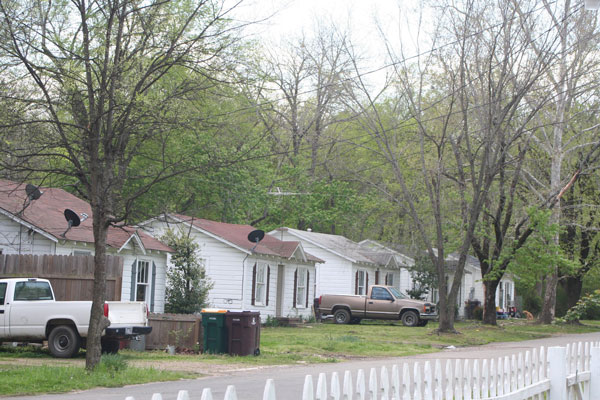
To visit the area today most of the homes in the residential areas south of Church Street are well cared for and yards are clean. The neighborhood has several rental properties, some better maintained than others. However, the South Howard Street District appears architecturally stable but somewhat run-down.
In 1983, as Brooks’ health began to fail, he sold the rental houses to Bill and Dorothy Stoball who were in the process of acquiring several rental properties. The Stoball’s sold the homes to their son David in 2003 and currently his brother Jeff is their caretaker.[22]
SIGNIFICANCE OF THE PROPERTY
These five buildings are prime examples of the 1940s Minimal Traditional style of architecture popular in the United States. Their weatherboard siding, flattened gabled roof and centered front entrance are all characteristic style features of the post World War II Minimal Traditional style home. The homes still display their original siding, windows, and even their open slat board and batten shutters—an important decorative element of this style. The homes are the only grouped example of this style of building in the historic districts of Morrilton. They serve as a quintessential example of this period of architectural construction and represent the growth of the residential area of Morrilton toward the east. As an unaltered collection of the Minimal Traditional style of architecture, the South Howard Street Historic District is being nominated to the Arkansas Register of Historic Places with local significance under Criterion C.
Bibliography
Conway County Historical Society, Conway County- Our Land, Our Home, Our People, (Historical Publication of Arkansas: Little Rock), 1992.
Deaton, Helen, “Lewisburg- River Port- Once Metropolis”, Arkansas Democrat, 2 April, 1954. Reprinted in Lewisburg: A Collection of Articles on Old Lewisburg. Obtained from Conway County Historical Preservation Association.
Haynie, Paul D. “Harding University”, Encyclopedia of Arkansas History and Culture, last modified 12 April 2012, accessed at www.encyclopediaofarkansas.net.
Historical Reminiscences and Biographical Memoirs of Conway County, Arkansas, (The Press-Argus: Van Buren, AR), 1890, reprinted 1967.
Hutchison, Jean. Interview. 2014.
Isley Jones, Mary. In Lewisburg 1910-1925, p. 13-14. Original source unknown. Reprinted in Lewisburg: A Collection of Articles on Old Lewisburg. Obtained from Conway County Historical Preservation Association.
“Lewisburg”, original source unknown, reprinted in Lewisburg: A Collection of Articles on Old Lewisburg. Obtained from Conway County Historical Preservation Association.
Madden, Mary and Swanda, Michael. Arkansas Historic Preservation Program’s Survey Manual. Architectural Style Descriptions. Appendix F, April 2001.
Massey, James C. and Maxwell, Shirley. Identification and Evaluation of Mid-20th-Century Buildings. (Massey Maxwell Associates: Alexandria, Virginia, October 2006).
McAlester, Virginia and Lee. A Field Guide to American Houses, New York: Alfred A. Knopf, 2002.
Moose, Eleanor. “Deserted Old Lewisburg Neighbor to Morrilton: Once Bustling city With Population of 1,200 in the Steamboat Days Now is Desolated by Ruins and Cut by Ravines”. Article in unknown newspaper. 25 Sept. 1927. Reprinted in Lewisburg: A Collection of Articles on Old Lewisburg. Obtained from Conway County Historical Preservation Association.
Rogers, Aaron. “Morrilton (Conway County)”, Encyclopedia of Arkansas History and Culture, last modified 1 May 2012, accessed at www.encyclopediaofarkansas.net.
Sanborn Maps, Morrilton, Arkansas, 1886, 1889, 1896, 1901, 1908, 1913, 1919, 1926, 1926-1948.
Stoball, Dorothy. Telephone Interview, 2014.
“Two Year Old Alyssa Jones Dies in Morrilton Building Collapse”, last modified 17 May 2011, accessed at www.TodaysTHV.com.
[1] Conway County Historical Society, Conway County-Our Land, Our Home, Our People, (Historical Publication of Arkansas, Little Rock: 1992), 26.
[2] Ibid, 26. Conway County Genealogical Society, Conway County Heritage- Then and Now, (Turner Publishing Company, Nashville: 2006), 162-163. Historical Reminiscences and Biographical Memoirs of Conway County, Arkansas (The Press-Argus, Van Buren, AR: 1890), 31.
[3] Historical Reminiscences, 33.
[4] Sanborn Map, 1886.
[5] Sanborn Map, 1901.
[6] Sanborn Map, 1908.
[7] Sanborn Map, 1926, 1948.
[8] Johnson, Antoinette, National Register Nomination for the Moose Addition Neighborhood Historic District, 2012, pg 12.
[9] Paul D. Haynie, Harding University, Encyclopedia of Arkansas History and Culture, accessed at www.encyclopediaofarkansas.net.
[10] Aaron W. Rogers, Morrilton (Conway County), Encyclopedia of Arkansas History and Culture, accessed at www.encyclopediaofarkansas.net.
[11] Sanborn Map, 1948.
[12] Sanborn Map, 1919 and 1926.
[13] U.S. Census, 1940.
[14] Dorothy Stoball, telephone interview with author, April 27, 2014.
[15] Sanborn Maps, 1948. U.S. Census Records, 1940.
[16] Jean Hutchison interview with author, Morrilton, Arkansas, April 25, 2014.
[17] Dorothy Stoball interview.
[18] Virginia and Lee McAlester, A Field Guide to American Houses, (New York: Alfred A. Knopf: 2002), 453.
[19] County Genealogical Society, Conway County Heritage-Then and Now, (Turner Publishing Company, Nashville: 2006),86. Historical Reminiscences and Biographical Memoirs of Conway County, Arkansas (The Press-Argus, Van Buren, AR: 1890), 68.
[20] Rogers.
[21] “Two Year Old Alyssa Jones Dies in Morrilton Building Collapse”, last modified 17 May 2011, accessed at www.TodaysTHV.com.
[22] Dorothy Stoball interview.