Listed in Arkansas Register of Historic Places on 04/01/09
SUMMARY
The Clarksville to Van Buren Road – Highway 352 Segment is eligible for listing on the Arkansas Register of Historic Places under Criterion A with Statewide
significance by virtue of its status as a modern highway overlaying the road traversed by the Harris, Whiteley and Bell Detachments during the Cherokee
Removal. The property is being submitted for Arkansas Register recognition under the multiple-property listing “Historic and Archeological Resources
Associated with the Cherokee Trail of Tears.”
ELABORATION
The Harris Detachment
In March 1834, Lt. Joseph Whipple Harris left the eastern United States with a party of 125 Cherokees and set out for the Indian Territory. Harris picked up hundreds of other emigrant Cherokee before crossing the Mississippi River and entering the Arkansas, and his detachment numbered more than 500, many of them sick with measles and other diseases, before arriving at Little Rock on April 6. The party continued on to Cadron settlement (NR listed on May 17, 1974) where a virulent outbreak of cholera killed dozens of Cherokee.[i]
On April 26, Harris, himself suffering from cholera, moved the detachment west across Cadron Creek, crossing Point Remove Creek on the 28th. On the 29th, he considered three possible routes to follow to Indian Territory: the Military Road south of the Arkansas and the upper and lower roads north of the river. Ultimately, he decided on the upper road, of which the nominated segment is a part, writing:
The upper road & new cut make, it is said, as direct a route as the military road. It will expose me to no delays, & of ferrying, there are good fords across the Illinois & the Piney, & though the new cut is nothing more than a blazed way through the woods – not a wagon track visible – very rough and here and there boggy, it will shorten our distance, including the delays of ferriage, a day’s journey; & will carry us through one or two flourishing settlements where I am sure of obtaining corn and bacon. [ii]
The Harris Detachment would have traversed the Dover to Clarksville Road – Hickeytown Road Segment (NR listed on May 26, 2005) on April 30, when he recorded in his journal “reached Parks near Piney 10 AM. Encamped at 4m/Beyond P’s on the ridge. Tolerable range and good water.” This ridge would have been at present-day Lamar, just west of the above-mentioned segment.[iii]
Harris continued west, recording that he “rode to Price’s (Pace’s) Mill on Horsehead Creek 4 miles.” Twitty Pace held several federal land patents in the area, the earliest dating to 1839, and may have been the owner of the mill Harris mentioned.[iv]
The Harris detachment continued west along the line of modern-day Highway 352, reaching Lasater’s near the Mulberry River at noon on May 6, 1834. While there, the officer wrote letters and caught up on paperwork. On May 10, the Harris Detachment arrived at its destination: New Dwight Mission in the Indian Territory. Of the more than 500 Cherokees in the party, 81 died during the journey and others would perish from the lingering effects of the hard journey and illness. Harris himself would die in 1837, his health destroyed by the cholera he suffered at Cadron.[v]
THE WHITELEY DETACHMENT
On June 13, 1838, a party of 875 Cherokees left Chattanooga, Tennessee, under Lt. R.H.K. Whiteley, who was assisted by five assistant conductors, two doctors, three interpreters and a hospital orderly.Traveling by water, the group entered the Arkansas River via the White River cutoff on July 4, then proceeded to Little Rock.[vi]
The Arkansas Times and Advocate reported on July 9:
Emigrating Cherokeess.-A party of 720 Cherokee Indians, under charge of Lieut. Whiteley, U. S. A. arrived here on Saturday last, on the s. b. Smelter, on their way to the West, and encamped on the north bank of the river, about half a mile above town, the water being too low for that boat to proceed, where they are now waiting for conveyance to Fort Gibson.[vii]
After switching to a lighter-draft steamboat, the Tecumseh, in order to navigate the drought-reduced Arkansas west of the state capital, the party proceeded on July 12 as far as Lewisburg (modern-day Morrilton) where they grounded on Benson’s Bar. On July 20, Whiteley procured 23 wagons and continued toward Indian Territory, leaving 80 sick Cherokees behind.[viii] He wrote in his journal the next day:
Procured more wagons and started the balance, much sickness & increasing, three, four, & five deaths per day. Diseases, measles & flux – caused by the use of green peaches & corn.[ix]
The Whiteley Detachment continued moving west, covering from 7 to 16 miles each day as the blistering Arkansas heat continued to take its toll of the sickly Cherokees. The party would have traveled the Dover to Clarksville Road – Hickeytown Segment on July 25 or 26; Whiteley’s journal entry for the 25th says: “Started the party before sunrise & encamped for the night at Piney.” While there, Josiah Giles and Dr. Robert Hodsen lodged at “Moreland’s on Piney Creek,” most likely Jeremiah Moreland who owned 240 acres in Section 21, Township 9 North, Range 22 West, which the road segment traversed. [x]
Continuing west, the detachment camped at “Little Spadney” on July 26, “Horsehead” on July 27, “White Rock” on July 28, “ Mulberry” on July 29, and “Frog Bayou”on July 30. Giles and Hodsen both filed claims for lodging at Russells on the 28th, which was likely Joseph Russell who owned land in Section 12, Township 10 north, Range 27 west just beyond White Rock Creek.[xi]
The detachment entered the Indian Territory on August 4, having traveled 1,554 miles, and Whiteley turned them over to an agent there on the 5th. His last journal entry reads:
Turned over the detachment to Mr. C. Nan as directed by Captain Stephenson and found the party in following size:
602 Indians present
65 Indians left the party, and went into the Nation after crossing the line.
70 deaths on the journey.[xii]
THE BELL DETACHMENT
The Cherokees who had signed the Treaty of New Echota traveled separately from their fellow tribesmen in a detachment that mixed-blood Cherokee John Bell conducted and for which U.S. Army Lt. Edward Deas was chief administrator. This detachment of some 660 Indians left the emigrating depot at Fort Cass near Charleston, Tennessee, on October 10, 1838.[xiii]
Deas reported that the Bell Detachment had crossed the Mississippi by November 24, 1838, noting that he “shipped up the Arkansas River a considerable quantity of the Baggage, Potware &c. &c, on very low terms, which I think will result in a good deal of saving in time and expense.”[xiv] This report is the last known to survive from Deas during his travels with the Bell Detachment, but historian Duane King has assembled Deas’s expense vouchers from the National Archives, providing an account of where and when the Bell Detachment traveled along the Memphis to Little Rock Road.
Deas’s vouchers show that the party crossed Blackfish Lake on November 28, when he paid H.N. Ferguson to ferry the Cherokee across (Blackfish Lake Ferry Site, NR listed April 10, 2003). Four vouchers show that the party purchased supplies from William Strong. Voucher #98 shows that on November 29 & 30, Strong ferried 650 Cherokees across the St. Francis River. Voucher #34 shows that on November 30, 1838, Deas purchased 50.5 bushels of cornmeal at $1 per bushel and 1,776 pounds of beef at 4 ½ cents per pound for at total of $130.42. Voucher #99, also dated November 30, shows Strong sold Deas 59 bushels of corn at $1 per bushel and 1,016 bundles of fodder at $4 per hundred bundles for at total of $99.64. Each of these vouchers was paid off on December 2. An unnumbered voucher dated December 1, 1838 reads: “Recd of Dr Eddington Four dollars for 1 gallon of French Brandy for the Cherokee Emigration.”Based on these vouchers, it probably was between November 30 and December 4 (the date of the last voucher paid in St. Francis County) that the Bell Detachment traveled the well-established Memphis to Little Rock Road segment that now traverses Village Creek State Park (NR listed April 11, 2003).[xv]
The detachment reached Little Rock by December 14 and stayed for three days, then followed the Military Road west. They reached Cadron on the 21st (Military Road – Cadron Segment, NR listed January 28, 2004) and crossed Cadron Creek the next day. They followed the Military Road as far as Lewisburg, then followed the same roads traveled by the Harris and Whiteley Detachments. Crossing Point Remove Creek on William Ellis’s Ferry on December 25, 1838, the group continued west and would have been on the nominated section by the 31st, when Deas bought supplies from A.E. Pace on Horsehead Creek. The party would have moved beyond the nominated road segment by January 5, when they bought supplies in Crawford County and Frog Bayou.[xvi]
The Bell Detachment traveled 707 miles in 89 days and disbanded at Vinyard Post Office (present-day Evansville) in Washington County, Arkansas, on January 7, 1839. Twenty-one of the 660 Cherokee Indians who began the journey in Tennessee died en route.[xvii]
[i]Grant Foreman, Indian Removal (Norman, OK: University of Oklahoma Press, 1953), 253-261.
[ii] Foreman, 260-1; Duane King, “The Emigration Route of the John A. Bell Detachment of Treaty Party Cherokees within the State of Arkansas, November 25, 1838 – January 7, 1839,” Research Paper, 2001, 23.
[iii] King, “Emigration Route,” 24; Duane King, “Punch List and Quadrangle Map Supplement for The Emigration Route of the John A. Bell Detachment of Treaty Party Cherokees within the State of Arkansas, November 25, 1838 – January 7, 1839, with Notations on the Whiteley, Drane and Harris Detachments of Emigrating Cherokees” Research Paper, 2002, 14.
[iv] King, “Punch List,” 13; information found athttp://files.usgwarchives.org/ar/johnson/land/johnson.txt, downloaded December 17, 2008.
[v] King, “Punch List,” 15; Stan Hoig, “Cadron” in Mark K. Christ and Cathryn H. Slater,Sentinels of History: Reflections on Arkansas Properties Listed on the National Register of Historic Places (Fayetteville, AR: University of Arkansas Press, 2000), 35.
[vi] Foreman, 294-5.
[vii] Quoted in the Arkansas Native Press Archives website athttp://anpa.ualr.edu/trail_of_tears/indian_removal_project/a_chronicle/cherokee.htm#1838, downloaded on January 4, 2005.
[viii] Foreman, 295.
[ix]Lt. R.H.K. Whiteley’s Journal of Occurrences, found athttp://www.mindspring.com/~wayne.gibson/JP1.gif, downloaded April 7, 2004.
[x] Whiteley Journal; King, “Punch List,” 13; Federal Land Patents for Jeremiah Moreland found at http://ftp.rootsweb.com/pub/usgenweb/ar/johnson/land/johnson.txt, downloaded on January 3, 2005.
[xi] King, “Punch List,” 14; Record of expenses, National Archives and Records Administration, RG 217, Box 276, File 2876G; information found athttp://files.usgwarchives.org/ar/franklin/land/franklin.txt, downloaded December 17, 2008.
[xii] Whiteley Journal
[xiii] King, “Emigration Route,” 4.
[xiv] Ibid., 7.
[xv] Ibid., 28-9; copies of vouchers from National Archives supplied by Duane King.
[xvi] Ibid., 17, 30.
[xvii] King, “Emigration Route, 4.
SIGNIFICANCE
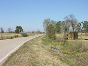
Though it is now covered by a two-lane, black-top highway, the Clarksville to Van Buren Road – Highway 352 Segment is eligible for listing on the Arkansas
Register of Historic Places under Criterion A with Statewide significance by virtue of its status as a modern highway overlaying the road traversed
by the Harris, Whiteley and Bell Detachments during the Cherokee Removal. While the paving compromises several elements of integrity, the remarkable
integrity of location, feeling and association make the highway segment richly deserving of recognition on the Arkansas Register of Historic Places.
The property is being submitted for Arkansas Register recognition under the multiple-property listing “Historic and Archeological Resources Associated
with the Cherokee Trail of Tears.”
BIBLIOGRAPHY
American Native Press Archives, found athttp://anpa.ualr.edu/trail_of_tears/indian_removal_project/
Mark K. Christ and Cathryn H. Slater, Sentinels of History: Reflections on Arkansas Properties Listed on the National Register of Historic Places (Fayetteville, AR: University of Arkansas Press, 2000)
Federal Land Patents, found athttp://ftp.rootsweb.com/pub/usgenweb/ar/johnson/land/johnson.txt
Grant Foreman, Indian Removal (Norman, OK: University of Oklahoma Press, 1953)
Duane King, “The Emigration Route of the John A. Bell Detachment of Treaty Party Cherokees within the State of Arkansas, November 25, 1838 – January 7, 1839,” Research Paper, 2001
_________, “Punch List and Quadrangle Map Supplement for The Emigration Route of the John A. Bell Detachment of Treaty Party Cherokees within the State of Arkansas, November 25, 1838 – January 7, 1839, with Notations on the Whiteley, Drane and Harris Detachments of Emigrating Cherokees” Research Paper, 2002
A. Mitchell, New Map of Arkansas, 1849, Arkansas History Commission
Lt. R.H.K. Whiteley’s Journal of Occurrences, found athttp://www.mindspring.com/~wayne.gibson/JP1.gif